 Newshot
Main
Plastic pollution, once thought to be a predominantly aquatic issue, is increasingly being recognized as a threat to terrestrial ecosystems1. Microplastics (synthetic polymer particles with diameter less than 5 mm) are a particularly problematic form of plastic pollution, as these small particles are easily dispersed through pathways that include atmospheric deposition, precipitation, river transport and groundwater flow2,3,4,5,6,7. The high environmental mobility of microplastics has allowed them to infiltrate even the most pristine habitats8 where they can persist for centuries9,10. For wildlife exposed to microplastics, the small size and diverse chemistry of these particles facilitate ingestion11 and the penetration of biological membranes12,13. Once internalized, microplastics can bioaccumulate, biomagnify through food webs and pose severe health risks14,15,16,17,18.
Although much work has been done on detecting microplastics in different biological compartments (reviewed in ref. 19), studies in terrestrial ecosystems have largely been limited to descriptive surveys that document the presence of microplastics without investigating how these pollutants accumulate within wildlife20,21,22. Although such studies have proven informative for identifying the scope and scale of plastic pollution, this approach has left the bioaccumulation dynamics of microplastics in terrestrial environments poorly understood. As a result of this knowledge gap, even high-profile studies on plastic ingestion risk in wildlife have had to rely on assumptions about the relationship between individual habitat use and the uptake of microplastics rather than empirically grounded associations23. Because both sources and dispersal pathways for microplastics are amplified by land-use change24,25,26, the intensity of human landscape modification should have a key role in shaping the internal microplastic burdens of terrestrial wildlife. Whether this is the case, however, is still largely unknown. With the continuing expansion of human-modified landscapes into wild spaces27 and the concomitant increase in global plastic production28, there is an urgent need to move beyond presence/absence studies and towards understanding the ecological and landscape-level factors that shape microplastic burdens in terrestrial species29.
Here we integrate movement ecology, land-use data and in vivo contaminant measurements within the same individuals to investigate how the intensity and proximity of anthropogenic land-use change shape systemic microplastic burdens in terrestrial mammals. The role of anthropogenic disturbance in shaping internal plastic burdens is particularly pressing in regions facing escalating environmental pressures, such as Brazil, where the extent of anthropogenic land-use change since the turn of the century has substantially outpaced the global average30,31 and deforestation, resource extraction, urbanization, agricultural intensification and an expanding road network are rapidly transforming the country’s landscapes30,32. By pairing in vivo microplastic measurements with high-resolution Global Positioning System (GPS) tracking data, we provide quantitative evidence that links individual-level habitat use and human landscape modification to systemic microplastic burdens in free-ranging terrestrial wildlife.
Land use shapes microplastic burdens
Between February 2021 and November 2022, we collected blood samples and high-resolution GPS-based movement data from lowland tapirs (Tapirus terrestris; n = 26) and giant anteaters (Myrmecophaga tridactyla; n = 21) sampled at the Arc of Deforestation in the Amazon, an agricultural mosaic in the Cerrado, and a relatively undisturbed cattle ranch in the Pantanal (Fig. 1a and Extended Data Table 1). For each individual, we quantified blood microplastic concentrations and polymer profiles using confocal Raman spectroscopy, detecting particles larger than 1 μm. We then paired these data on in vivo microplastic burdens with the GPS tracking data to understand how inter-individual differences in habitat use and disturbance exposure shaped internal microplastic burdens. In particular, we quantified each individual’s exposure to human disturbance through the Human Footprint Index (HFI), a globally standardized measure of cumulative anthropogenic pressure ranging from 0 (undisturbed) to 50 (most heavily modified)33. We also examined local-scale effects through each animal’s proximity to the nearest human development (that is, the built environment including urban areas, mining infrastructure and power plants)34 and waste management facilities34.
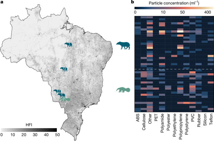
a, Locations of the monitored lowland tapirs (blue, n = 26 animals) and giant anteaters (green, n = 21 animals) throughout Brazil, overlaid on top of the HFI. The numbers depict the sample sizes within each study area. b, Heat map depicting the concentration of the analysed microplastic polymers for lowland tapirs (blue) and giant anteaters (green). Each row in the heat map corresponds to an individual animal. Polymers categorized as ‘other’ were those that occurred at low abundance, and included polyvinyl butyralolyethyleneimine, poly(butylene terephthalate), polyvinylformal, polyacetal, polymethylpentene, polyurethane and polyethylene glycol. Giant anteater image credit: Steven Traver via PhyloPic (CC0 1.0); tapir image credit: Christophe Mallet via PhyloPic (CC0 1.0).
Across all samples, we identified a total of 17,165 particles with a hit quality index (HQI) > 75, of which 2,815 (16.4%) were identified as microplastic. Microplastics were near-ubiquitous and found in the blood of all but four animals (three giant anteaters and one tapir), but systemic concentrations varied markedly across individuals (mean: 73.8 particles per ml; range 0 to 1,211.3 particles per ml). Lowland tapirs had the highest microplastic burdens (98.9 particles per ml; 95% confidence interval 52.0–188.0 particles per ml), followed by giant anteaters (42.8 particles per ml; 95% confidence interval 26.7–68.6 particles per ml); however, concentrations did not differ significantly between species (β = 0.84, t = 1.88, P = 0.067). Tapirs and giant anteaters did differ in polymer composition (Fig. 1b, Extended Data Fig. 1 and Supplementary Information), with additional inter-individual variation detailed in the Supplementary Discussion and Extended Data Fig. 2. Although comparable data on systemic microplastic burdens are not presently available for other species of terrestrial wildlife, the mean concentration of 73.8 particles per ml found in these animals is within the range reported in human blood using spectroscopic methods35 (1.9 to 108 particles per ml).
Across species and sampling sites, individual differences in blood microplastic burdens were consistently associated with anthropogenic disturbance. Of the 47 animals from which blood samples were collected, 40 had sufficient GPS tracking data for inclusion in the habitat use analyses. These animals spanned a wide gradient of human pressure (Fig. 2a), with the maximum HFI individuals experienced ranging from as low as 2.6 to 40.5. The home ranges of these animals were 12.6 km from the nearest human development on average, ranging from 95 m to 67.4 km. There was a significant positive relationship between blood microplastic concentrations and the maximum HFI within an animal’s home range (β = 0.07, t = 2.66, P = 0.011; Fig. 2b), although weighted mean HFI exposure was non-significant (β = 0.061, t = 1.73, P = 0.092; Extended Data Fig. 3).
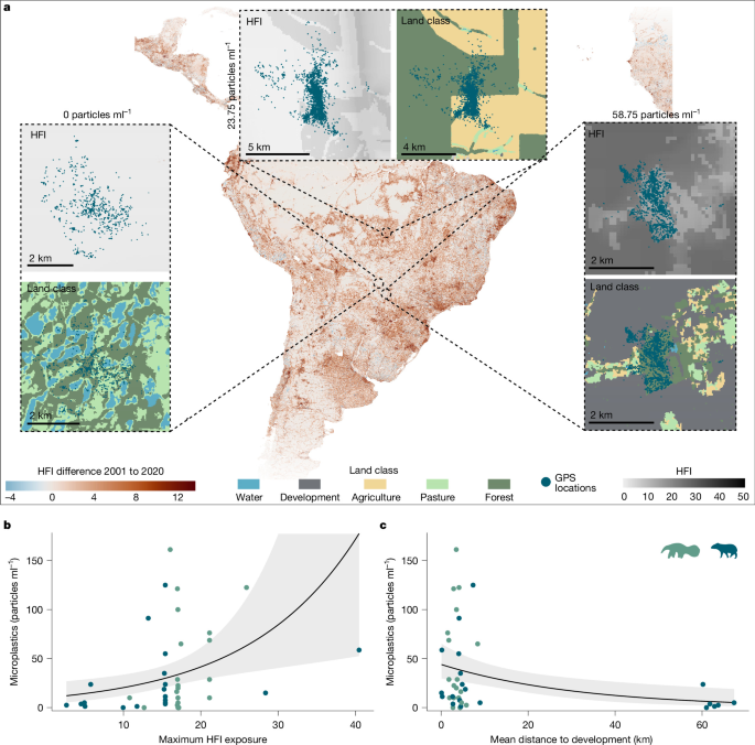
a, Map of the difference in the HFI between 2001 and 2020; examples of HFI and animal movement, as well as land-use class and animal movement data (scatter points), are shown for animals with high, medium and low blood microplastic concentrations. b,c, The scatter plots (n = 20 lowland tapirs and 20 giant anteaters) show the relationships between microplastic concentrations and the maximum HFI in home range (b; β = 0.07, t = 2.66, P = 0.011) and the mean distance to development (c; β = −0.032, t = −2.94, P = 0.0057). Lines in b,c show the fitted population-level trend from a hierarchical generalized linear model (Tweedie distribution; log link) with species-specific random intercepts and slopes; shaded bands are 95% confidence intervals. P values are based on two-sided tests, with no correction for multiple comparisons; coefficients are on the link scale. Giant anteater image credit: Steven Traver via PhyloPic (CC0 1.0); tapir image credit: Christophe Mallet via PhyloPic (CC0 1.0).
Although these results highlight how direct exposure to human-modified landscapes shapes internal microplastic burdens, plastic pollution is a transboundary issue with complex dispersal pathways36. Atmospheric deposition and waterborne transport are likely contributors, as airborne microplastics from urban, industrial and agricultural sources can travel long distances before settling in remote ecosystems, and rainfall runoff, river discharge and seasonal flooding redistribute particles across landscapes to habitats far from their original sources2,3,4,5,7,37. Focusing on direct HFI exposure alone can obscure such effects. Indeed, we found that the local-scale effects of human land use were particularly important in shaping the systemic microplastic concentrations of the monitored animals, with significant effects of distance to development (β = −0.032, t = −2.94, P = 0.0057) and distance to the nearest waste management facility (β = −0.026, t = −2.73, P = 0.0096) (Fig. 2c and Extended Data Fig. 3). Additional data on giant armadillos (Priodontes maximus) living in the Pantanal corroborate this trend (see Supplementary Discussion). These relationships were all robust to sensitivity analyses (Extended Data Tables 2 and 3 and Supplementary Discussion) and highlight the role of anthropogenic land use in driving species’ exposure to plastic pollution. The polymer profiles also varied across sampling sites in patterns that were broadly consistent with the dominant human activities at each site (Extended Data Figs. 4 and 5 and Supplementary Discussion).
Microplastics scale with human pressure
Recent estimates38 reveal that the mean global HFI increased from 5.26 in 2001 to 6.63 in 2020, representing a 26% increase. This trend in land-use change was even more pronounced in Brazil, where the HFI rose by 42% over the same period, from 4.17 to 5.92. Problematically, anthropogenic land-use expansion often outpaces the development of waste management infrastructure39,40. This infrastructural gap leaves regions experiencing the most rapid change the least equipped to contain plastic waste. Across large parts of rural and interior Brazil, for example, solid waste collection remains inadequate and wastewater treatment is limited or absent altogether41,42,43. The plastic materials tied to the expanding human footprint thus have few barriers preventing them from becoming highly mobile environmental pollutants42. The relationship between human disturbance and blood microplastic concentrations identified here suggests that microplastic burdens in terrestrial wildlife will continue to rise as land-use change intensifies. Notably, even at an HFI of zero the model predicted blood microplastic concentrations of 10.5 particles per ml (95% confidence interval 4.6–24.2 particles per ml; intercept: β = 2.36, t = 5.58, P < 0.001). While we can not discount the potential that this non-zero intercept was the result of an unmodelled non-linear relationship at low HFI exposure, it does provide support that direct exposure to human-modified landscapes is unlikely to be the sole driver of systemic microplastic burdens. The seemingly pervasive reach of microplastic pollution is most strikingly illustrated by our findings from the animals in the Pantanal. The Pantanal is the world’s largest and most pristine wetland, supporting an extraordinary diversity of wildlife within a relatively undisturbed landscape44. Unlike other biomes in Brazil, much of the Pantanal has remained ecologically intact owing to its remote location, limited infrastructure and seasonal flooding, which naturally regulate many human activities. Yet, we found microplastics in the blood of all of the individuals we sampled in the Pantanal, despite these animals living more than 65 km from the nearest development and more than 112 km from the nearest waste management facility. This finding is corroborated by several recent studies that reported substantial concentrations of microplastics in both aquatic environments and sediments throughout the Pantanal45,46,47, with the highest levels of microplastics (up to 1,174.2 items per m2) found near rivers flowing from urban areas46. The presence of microplastics in the blood of animals living many tens of kilometres from the nearest development or waste facility highlights how microplastics are a threat not only to wildlife with direct exposure to human-modified landscapes, but also to species across even the most remote and ecologically intact environments8. Developing a mechanistic understanding of the pathways through which microplastics reach remote terrestrial ecosystems will be essential for protecting wildlife from this highly mobile pollutant. Although environmental sampling across these sites would strengthen the causal inference of these relationships by directly linking environmental polymer profiles to those detected in blood, isolation protocols for chemically diverse samples such as blood and soil complicate spectroscopy-based comparisons48,49. Paired blood–environment sampling designs thus represent a productive, albeit challenging path forward.
By combining in vivo microplastic measurements with fine-scale movement data and high-resolution landscape disturbance indices, our study moves terrestrial microplastic research beyond detection surveys towards a spatially informed quantitative framework for predicting wildlife burdens from landscape context. This approach revealed how individual habitat use and anthropogenic land-use change interact to shape wildlife exposure to microplastics, and is readily transferable to other species and regions, offering a scalable tool for identifying vulnerable populations and informing targeted conservation responses. While no ecosystem is likely to be entirely free of microplastics50, we did find that animals in less disturbed habitats carried substantially lower burdens than those in close proximity to human infrastructure. These findings suggest that management efforts aimed at limiting animals’ exposure to human-modified environments and reducing their proximity to development and waste management infrastructure can serve to reduce the microplastic burdens carried by wildlife.
Methods
Sampling areas
Lowland tapirs
Lowland tapir (T. terrestris) samples were collected across three sites in Brazil. The agricultural mosaic site in the Cerrado was located between the municipalities of Nova Alvorada do Sul and Nova Andradina, in Mato Grosso do Sul State, Brazil (−21.99° N, −53.83° E). It features a mosaic of natural habitats, including Cerradão fragments, gallery forests and marshlands, which constitute approximately 12% of the study area. The remainder is heavily influenced by human activities, including agriculture (for example, sugarcane, soybean and corn), cattle ranching, eucalyptus plantations, highways and rural settlements. Precipitation exhibits marked seasonality, with approximately 70% of the total annual rainfall occurring between November and March51.
The field site in the Pantanal was situated on Baía das Pedras Ranch, in the Nhecolândia Sub-Region of the Southern Pantanal, Municipality of Aquidauana, Mato Grosso do Sul State, Brazil (−19.33° N, −55.72° E). This private property spans 145 km² and comprises a mosaic of seasonally inundated grasslands, lakes, gallery forests, scrub, and deciduous forests. The Pantanal is a nearly pristine biome with a low human footprint, and is far removed from areas experiencing deforestation and other anthropogenic pressures. The ranch supports abundant wildlife and extensive cattle grazing on native grasses. The average annual temperature is 25 °C, and the annual rainfall is 1,185 mm.
The site in the Amazon was located at Tanguro Farm, a privately owned 103,000 ha property in Querência, Mato Grosso state, that sits at the transition between the Cerrado savanna and the Amazon rainforest along the southern Arc of Deforestation. Owned by AMAGGI, a major actor in Brazil’s soybean industry, the farm comprises 59,000 ha (57%) of croplands (soybean, corn, and cotton) and 44,000 ha (43%) of legally protected forest reserves. This region is the driest portion of the Amazon basin and experiences a prolonged dry season (May–September) with annual rainfall of 1,700–2,200 mm. Forests in this region are shorter (~20 m) than the moist Amazon rainforest (~30 m). About 40% of the farm was cleared for pasture (1976–1992) and later converted to soy cultivation (2003–2010), leaving riparian forests surrounded by croplands.
Giant anteaters
The giant anteater (M. tridactyla) data collection was conducted in the Cerrado savanna of Mato Grosso do Sul state, Brazil, as part of the Anteaters and Highways Project (ICAS, www.icasconservation.org.br), which investigates wildlife-vehicle collisions and their impacts on wildlife populations. Sampling areas were located near two federal roads: BR-267 (−21.64° N, −53.51° E) and BR-262 (−20.86° N, −52.04° E). As described above, the study region is a mosaic landscape dominated by open areas, including grasslands, pastures, and croplands, interspersed with small remnants of native savanna and forest vegetation, as well as eucalyptus plantations52.
Giant armadillos
In addition to the tapir and giant anteater data, we also obtained a smaller amount of data from three giant armadillos (P. maximus). The giant armadillo data collection was also conducted at the Baía das Pedras Lodge and Ranch in the Pantanal, which served as the base of operations for the Giant Armadillo Conservation Program (GACP).
Animal captures and GPS data acquisition
Ethics statement
All animal capture, handling, and blood sampling procedures were approved by the Brazilian Ministry of the Environment (MMA) and the Chico Mendes Institute for Biodiversity Conservation (ICMBio) under license numbers 14603-25 (lowland tapirs), 53798-18 (giant anteaters) and 27587-1 (giant armadillos). All procedures were performed in accordance with the terms of these licenses and with relevant national and institutional animal welfare guidelines. Chemical immobilization was performed under veterinary oversight, and all animals were released at their capture sites following full recovery.
Lowland tapirs
Lowland tapirs were captured using a combination of methods, including darting, following physical restraint in box-traps or pitfall traps, or darting from a distance. Box traps and pitfall traps were deployed in areas frequently visited by tapirs. Tapirs captured by these methods were anaesthetized intramuscularly with a combination of butorphanol (0.17 mg kg−1), medetomidine (0.012 mg kg−1) and ketamine (0.7 mg kg−1). Reversal agents, including atipamezole (0.04 mg kg−1) and naltrexone (0.35 mg kg−1), were administered at the conclusion of procedures. For tapirs darted from a distance, anaesthetics included tiletamine-zolazepam (1.25 mg kg−1), medetomidine (0.006 mg kg−1), ketamine (0.6 mg kg−1) and atropine (0.03 mg kg−1). Darts (3 ml or 5 ml) were used to deliver anaesthetics. Midazolam (0.03 mg kg−1) was administered 30 min later to maintain anaesthesia. Captured tapirs underwent a range of procedures, including subcutaneous microchip insertion, morphometric measurements, sex and age determination, physical examinations, blood sample collection and telemetry collar placement for adults.
Tapirs were equipped with GPS collars (Telonics TGW SOB and GPS IRIDIUM models) programmed to obtain hourly location fixes, with a median operational life of 15.4 months. Additional location data were collected from stationary tags placed in the Pantanal (n = 883) and Cerrado (n = 174) to calibrate the measurement error in the GPS datasets.
Giant anteaters
Giant anteaters were captured between February 2021 and November 2022 using motorized active searches between 15:00 and 17:00, when they exhibit higher diurnal activity due to colder temperatures53,54. Searches were conducted along dirt roads in open areas, with two team members stationed in the back of a truck to improve detectability. Upon spotting an individual, technicians approached the animal on foot and captures were performed using two long-handled dip nets (1.5 m handles, 0.7 m diameter hoops). Physical capture typically lasted around 1 min.
Captured giant anteaters were chemically immobilized, equipped with GPS radiotelemetry harnesses (Telonics) as previously described55 and blood samples were collected. In brief, animals were anaesthetized using a protocol of butorphanol tartrate (Zoetis Indústria de Produtos Veterinários; 0.1 mg kg−1), detomidine hydrochloride (Agener-União; 0.1 mg kg−1) and midazolam hydrochloride (Cristália; 0.2 mg kg−1), adapted from ref. 55. The induction period averaged 8.27 ± 4.78 min.
Giant armadillos
Giant armadillos were captured between February 2021 and November 2022, using a method tailored to their natural behaviour56. Researchers tracked footprints and signs of recent predation, such as termite mounds, to locate burrows. When a burrow was identified and confirmed to contain an armadillo (indicated by the entrance being sealed with sand), an iron funnel trap (jequi-type) was placed at the entrance. Once captured, animals were transported in iron-reinforced wooden crates and held overnight for nocturnal species, with procedures beginning the following morning at the capture site.
Captured giant armadillos were anaesthetized for the collection of blood samples and surgical implantation of intra-abdominal transmitters. Anaesthetic protocols included an intramuscular injection of butorphanol tartrate (0.1 mg kg−1), detomidine hydrochloride (0.1 mg kg−1), and midazolam hydrochloride (0.1 mg kg−1) into the hind limbs. Before surgery, intradermal local anaesthesia with lidocaine hydrochloride (2 mg kg−1, Eurofarma) was infiltrated into the infra-umbilical region. Ketamine hydrochloride (10 mg kg−1) was administered intramuscularly as a supplementary anaesthetic immediately after the animals were completely washed. Transmitters (IMP 310 model, Telonics; 9.4 × 2.3 cm, 42 g, 36-month operational life) were surgically implanted within the abdominal cavity under sterile conditions. Following surgery, anaesthesia was reversed using a combination of naloxone hydrochloride (0.02 mg kg−1), yohimbine hydrochloride (0.125 mg kg−1), and flumazenil (0.01 mg kg−1). Armadillos were released at their capture sites upon recovery, typically remaining in their burrows for 24 to 120 h (average of 48 h) before emerging. Daily monitoring was conducted for 12–22 days post-release using telemetry receivers (model TR-4, Telonics) and VHF antennas (model RA-23K). After the initial monitoring period, armadillos were monitored monthly until the end of the transmitter’s operational life.
Blood sample collection
Lowland tapirs
Approximately 10 ml of blood was collected within 20 min of immobilization via venipuncture of the medial saphenous or cephalic veins using a sterile glass vacutainer system (BD Vacutainer). Tapir captures were conducted in remote forest sites without access to field refrigeration. Blood samples were therefore stored in pre-cleaned glass collection tubes with no preservatives, sealed with clean aluminium foil and a metal cap to prevent contamination during storage, kept shaded at ambient temperature, and transferred to a −20 °C freezer on return to the base camp within 5–6 h.
Giant anteaters and giant armadillos
Blood samples (~5 ml) were collected approximately 20 min after induction from the cephalic or saphenous veins using a sterile vacutainer system with 23G or 25G needles (BD Vacutainer). Samples were transferred to pre-cleaned glass collection tubes with no preservatives, sealed with clean aluminium foil and a metal cap to prevent contamination during storage, kept refrigerated at 4 °C on site, and frozen at −20 °C within 12–24 h for subsequent processing. We note that blood samples were obtained from three individual giant armadillos, however we obtained repeat samples at two time points for two of these animals. Although these blood samples were processed individually, they were pooled (that is, averaged) in our statistical analyses.
Cold storage under the above-mentioned conditions is standard practice in microplastic analyses and does not affect particle abundance or polymer identity. Microplastics are chemically stable over these timescales, and method reviews emphasize that environmental samples containing microplastics are routinely stored at 4 °C for days to weeks prior to processing, or frozen at −20 °C for longer periods, without alteration of polymer composition (reviewed in ref. 57).
Microplastic isolation from blood
Blood microplastic isolation was performed following a protocol previously developed by our team58,59,60. Depending on the sampling date, blood samples were stored at −20 °C for ~1–22 months between collection (Feb 2021–Nov 2022) and digestion (Dec 2022). On the first day of isolation, 1 ml of each blood sample was placed in an Erlenmeyer flask along with 50 ml of 10% KOH solution (sample ratio of 1:50). The mixture was incubated on a shaker at 60 °C and 250 rpm for 24 h. After the initial 24-h incubation, 10 ml of 47% NaClO were added to each sample to achieve a final concentration of 7.7%. The samples were then incubated under the same conditions (60 °C and 250 rpm) for an additional 24 h.
Following the second day of digestion, all samples were filtered through a 47 mm polytetrafluoroethylene (PTFE) membrane with a 0.45 μm pore size (Merck Omnipore) and rinsed 3 times with filtered ultrapure water. The membranes containing the particles were then submerged in 50 ml of 20% HNO3 and placed in an ultrasonic bath with sweep function at 100% power and 45 kHz frequency for 15 min to transfer the particles from the membrane to the solution. The samples were further incubated for 30 min at 40 °C and 250 rpm.
After removing the membranes, the samples underwent a 24-h incubation at 40 °C and 250 rpm. On the final day, the samples were filtered through a 13 mm PTFE membrane with a 0.45 μm pore size, rinsed three times with filtered ultrapure water, and mounted on glass slides for microscopy and spectroscopy analysis. The resulting filter membranes were then stored in pre-cleaned glass Petri dishes and analysed by Raman spectroscopy over the subsequent ~12 months (Jan–Dec 2023). After digestion, a proportion of non-plastic particulates remained on the membrane, such that microplastics accounted for an average of 16.4% of imaged particles with HQI > 75 (range 0–89.9%).
Quality assurance and quality control methods used throughout the process are detailed in the Supplementary Methods (see also Extended Data Figs. 6 and 7).
Confocal Raman analysis of particles
Microplastic identification and characterization were conducted using a confocal Raman microscope (alpha300 R, WITec) equipped with a UHTS 300 spectrometer (WITec) and a 532-nm laser. The microscope was operated using Control Five software, and the acquired data were processed with Project Five software to compensate for background noise and cosmic radiation signals.
As an initial step, a whole membrane image was captured using a 10× NA 0.25 Zeiss objective with the Area Stitching option. From this image, a specific field was selected for detailed imaging with a 50× NA 0.75 Zeiss objective, employing both the Area Stitching option and Z-stack autofocus. Particle identification was facilitated by the Particle Scout software, which enabled the acquisition of Raman spectra for all identified particles across the entire membrane. Raman spectra were then obtained using a 100× DIC NA 0.9 Zeiss objective, with a laser power of 10 mW, an accumulation of 4, and an integration time of 0.45 s. Spectra autofocus was used throughout the measurements. The acquired spectra were then compared against the S.T. Japan database (S.T. Japan Europe GmbH) and the SLoPP MPs Raman library61 using the True Match-Integrated Raman Spectra Database Management software. Microplastic characterization was based on an automated, 3-step process that was optimized for spectra acquisition rather than image sharpness. This precluded the manual assessment of particle shape (for example, fibres or fragments) or colour. Only matches with an HQI greater than 75% were considered for further analysis.
HFI differences between 2001 and 2020
To assess changes in the HFI over time, we obtained and processed global HFI rasters at a 300 m resolution for the years 2001 and 2020 from the Wildlife Conservation Society Human Footprint dataset (https://wcshumanfootprint.org/). After ensuring projections and resolutions were consistent between the HFI rasters, a difference raster was generated by subtracting the 2001 HFI from the 2020 HFI to visualize areas of increasing and decreasing human influence. We cropped and masked the HFI rasters to remove areas outside of Brazil and then computed the mean HFI for 2001 and 2020, as well as the absolute differences. These analyses were conducted in R using the terra (v1.8-54)62, sf (v1.0-21)63,64, tmap (v4.0.0.9000)65, fields (v16.3)66, rnaturalearth (v1.0.1)67, and geobr (v1.9.1)68 packages.
Animal movement analysis
Movement data pre-processing
Before analysis, we pre-processed the GPS location data in order to calibrate the measurement error and filter outliers. Pre-processing was done via the methods implemented in the R package ctmm (v1.2.1)69. For each location estimate, the GPS trackers recorded a unitless Horizontal Dilution of Precision (HDOP), a value which is a measure of the accuracy of each positional fix. We converted the HDOP values into calibrated errors by specifying 20-m error at an HDOP of 1 for 2D fixes, and 10-m error at an HDOP of 1 for the 3D fixes70. For each individual dataset, we then removed outliers based on error-informed distance from the median location, and the minimum speed required to explain each location’s displacement. Through this process we identified a total of 16,656 outliers, which represented ca. 3.55% of the total 469,410 locations. After filtering outliers, the final dataset consisted of 343,913 GPS locations across 20 individual giant anteaters, 6,072 GPS locations across 2 individual giant armadillos, and 102,769 GPS locations across 20 individual lowland tapirs.
Movement modelling
For each of the tracked animals, we used a continuous-time approach to estimate their movement rates and home ranges, enabling robust comparisons across individuals71. We first fitted a series of continuous-time stochastic process movement models to the location data. Parameters were estimated using perturbative-hybrid residual maximum likelihood (pHREML)72, and identified the best model via small-sample-sized-corrected Akaike’s information criterion (AICc). From both visual inspections of the semi-variograms, and the parameters of the fitted movement models, all animals occupied stable home ranges throughout the monitoring period with no indication of range shifts or large-scale dispersal events.
From the selected models, we estimated each animal’s diffusion rate (in km2 day−1) as a measure of their movement rate. We next estimated each animal’s home range, using autocorrelated kernel density estimation (AKDE)73. AKDE home range estimates were conditioned on the autocorrelation structure of the fitted movement model, and we implemented the small-sample-size bias correction of Fleming & Calabrese (2017)74, as well as the optimal weighting of Fleming et al. (2018)75 to correct for uneven sampling. Home range areas (in km2) were estimated as the area contained within the polygon delimited by the 95% isopleth of the probability density.
We estimated the mean and maximum HFI within each individual’s home range. HFI is an aggregate measure of human disturbance that ranges from 0 in natural habitats to 50 in the most anthropogenically modified habitats33. A raster of HFI data with a spatial resolution of 100 m was obtained from Gassert et al.38. The weighted mean HFI within an individual’s home range was estimated by calculating the weighted arithmetic mean of HFI values:
with weights (wu) determined by the probability density at each location u. Maximum HFI exposure was estimated by identifying the maximum value of HFI within each animal’s home range. We also estimated more nuanced patterns of habitat use via the MapBiomas database34, which details land use throughout Brazil at a spatial resolution of 10 m. We focused on habitats classified as water, development, agriculture, pasture, and native forest, which represented the majority of the land classes within the monitored animals’ home ranges. The proportions of each of these land classes within each animal’s home range were again estimated by calculating the weighted arithmetic mean. Lastly, we used the MapBiomas land classification data, the Rocky Mountain Institute (RMI), and the Waste Methane Assessment Platform 1.5.0, 2025 (https://wastemap.earth) to generate spatial rasters of distance to development, and distance to the nearest waste management facility (both in m). Development was a compound measure that captured the built environment, and was composed of the MapBiomas collection 10 classes: urban areas (24), mining (30), photovoltaic power plants (75), and other non-vegetated areas (25). From these spatial data, we estimated each animal’s mean distance to development and to the nearest waste management facility, estimated by calculating the weighted arithmetic mean.
Statistical modelling
To study how human land-use change shaped blood microplastic concentrations, we fit hierarchical generalized linear regression models using the methods implemented in the mgcv package (v1.9-1)76. Because the microplastic concentrations scaled between [0,∞], we used a Tweedie distribution with a log link for the error distribution77, with parameters estimated via restricted maximum likelihood (REML). The regression models testing for correlations between individual habitat use and microplastic concentrations included a population-level effect, as well as random intercepts and slopes for each of the species, with the following general form
where β0 represents the population-level intercept, β is the population-level slope, us[i] is the species-specific random intercept, vs[i] is the species-specific random slope, and s[i] indexes the species of individual i. This structure was used for all of the habitat covariates xi. From these models, inference was then made on the population-level trend.
All analyses were conducted in R (v4.3.3). Weighted means and proportions of land-use exposure were computed with the weights package (v1.0.4). Figures were produced with ggplot2 (v3.5.2), ggspatial (v1.1.9), tidyterra (v0.7.0), rphylopic (v1.5.0; animal silhouettes), fmsb (v0.7.6) and gridExtra (v2.3).
Statistics and reproducibility
No statistical method was used to predetermine sample size. Sample sizes were determined by the number of animals that could be safely captured during the study period (February 2021 to November 2022) given the logistical constraints of live-capturing large, threatened, free-ranging mammals under national permits, and all animals captured during this period were sampled. This was an observational field study, so randomization was not applicable; animals were not allocated to experimental groups, and exposure to human land use was determined by each individual’s own space use. The investigators were not blinded to species or sampling site during laboratory processing or analysis; however, particle detection and polymer identification were automated (Particle Scout and True Match software) and based on a fixed spectral-match threshold (HQI > 75%), which limits observer bias. Each animal contributed one blood sample, with the exception of two giant armadillos sampled at two time points, whose values were averaged before analysis. Seven animals lacked sufficient GPS tracking data and were excluded from the habitat use models but retained in descriptive analyses. Samples were processed in two batches, each with a procedural blank (Supplementary Methods); all lowland tapir samples were processed in the same batch. The polymer-integrity test shown in Extended Data Fig. 6 was repeated three times independently with similar results.
Reporting summary
Further information on research design is available in the Nature Portfolio Reporting Summary linked to this article.